Incessant rains have brought Bengaluru face to face with a flood-like situation. As torrential rains drenched the city, many places in Bengaluru had the authorities sending rafts to evacuate people to a safer zone. The most affected areas include Bellandur, Sarjapura Road, Whitefield, Outer Ring Road, and BEML Layout. This list is not exhaustive.
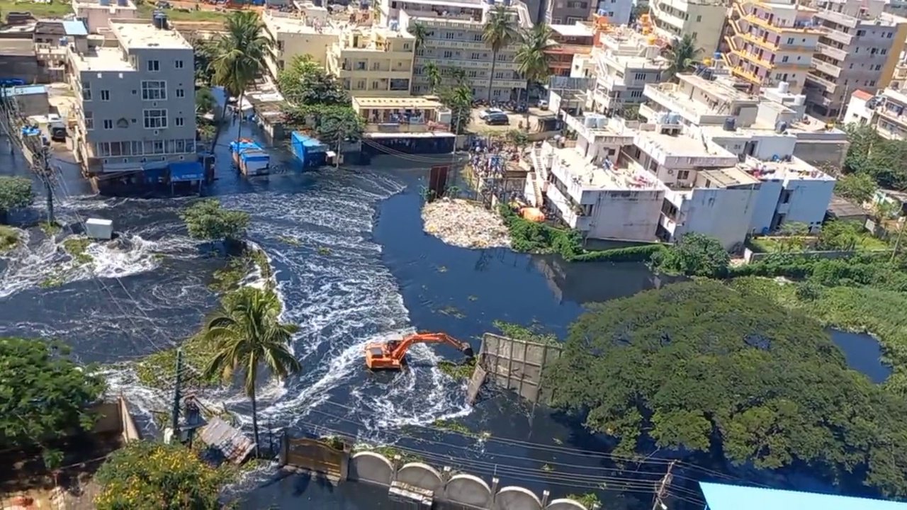
Reports state that the thunderstorm that began around 8 pm on Sunday night was a result of a cloud burst. Last night was recorded as the wettest day for the city.
Max of 148mm in ksndmc numbers. Quite a few places above 10cm.
— Bengaluru Weather (@BngWeather) September 5, 2022
Whitefield private AWS records 17+ cm! #bengalururains pic.twitter.com/iaZg4Li2DJ
Netizens have posted visuals from different parts of the city that show the flooded streets. The roads are blocked and some neighbourhoods have been rendered inaccessible. As a result, the remaining roads are seeing massive traffic jams.
#WATCH | Karnataka: Massive traffic jam on Marathahalli-Silk Board junction road in Bengaluru amid severe waterlogging caused due to heavy rainfall pic.twitter.com/KUnF0cuPtR
— ANI (@ANI) September 5, 2022
This visual from the Bellandur bridge shows how the area has been completely waterlogged.
Bangalore rains hit hard on Sunday night!!#bangalorerains #bangaloretraffic #bellandur #bellandurbridge pic.twitter.com/vVdxRER9yY
— nsrivastava.eth (@nitinkr1991) September 5, 2022
Bengaluru airport was also waterlogged. Visuals show citizens wading through water.
Bangalore Airport is so beautiful..!!ಎಷ್ಟೊಂದು ಸುಂದರ ಬೆಂಗಳೂರ್ ವಿಮಾನ ನಿಲ್ದಾಣ..@BSBommai @JnanendraAraga @bbmpcommr #BengalureAirportrain pic.twitter.com/weaVEJylKP
— sulaiman kallarpe (@sulaimankallar7) September 5, 2022
Ecospace has vehicles almost sinking in the water.
Situation is terrifying at #Ecospace near Bellandur.
— Gautam (@gautyou) September 4, 2022
Vehicles are quite literally sinking.
Time 11:30 pm when this was shot… and rains show no sign of relenting.#bengalururains #Bengaluru pic.twitter.com/nSiRsqisQK
The IT corridors of Bengaluru are also witnessing major waterlogging.
Rains coupled with poor planning & infrastructural woes has brought several parts of #Bengaluru to its knees once again. Most areas in the #IT corridor once again #flooded. Traffic piling up due to #waterlogging as well.
— Deepak Bopanna (@dpkBopanna) September 5, 2022
Rainbow drive layout Sarjapura (1) pic.twitter.com/mh83weBENc
Here are some visuals from other parts of Bengaluru.
The tractors are back out in #Bengaluru‘s residential layouts 🚜
— Gautam (@gautyou) September 5, 2022
This is from the posh Sunny Brooks Layout at Sarjapur road.
Is it time for RWAs to consider investing in tractors as a mode of transport arnd the community during rains?#BengaluruRain pic.twitter.com/JCIqfOxYJc
Citizens rescue BMTC bus at Whitefield Main Road #bengalururains pic.twitter.com/GJx4Zx3Kva
— Anant Patil (@ADnant) September 5, 2022
Thank you @CMofKarnataka @BSBommai you have developed our city to European Standards.
— Kamran (@CitizenKamran) August 29, 2022
Now Indiranagar has started to look like Venice.
Please increase your corruption from 50% to 100% we will then be Venice for 365 days. Now this pleasure is only short lived#bengalururains pic.twitter.com/WXwVq15oBk
Massive tree falls on man & woman driving in the car early this morning in Pulikeshinagar! Both are safe, thankfully. Aftermath of #BengaluruRains pic.twitter.com/gPpYGhpGx1
— Mohammad Abdullah (@Adrashbhart) September 5, 2022
One more apartment in East Bengaluru.
— Citizens Movement, East Bengaluru (@east_bengaluru) September 4, 2022
Residents are helplessly watching their basement getting flooded!#bengalururains #Bengaluru pic.twitter.com/M0EezW3yWV
Visuals from Manyata Tech Park. Asia’s IT capital #Bengaluru, #Karnataka.#Bangalore #BBMP #BengaluruRains #BengaluruFloods #SpiritOfBengaluru #ManyataTechPark pic.twitter.com/HuePpAyiNb
— Hate Detector 🔍 (@HateDetectors) September 5, 2022
1&2 Balagere-Panathur road in Varthur
— Sarath Chandra B+ Blood Group (@sambhadu) September 5, 2022
3&4. Sarjapur Road#bengalururains #bengaluru pic.twitter.com/Xwr9Egb6TY
A yellow warning has been issued to several districts of Karnataka. Fishermen have asked not to venture into the sea as the speedy winds have been predicted. The Indian Meteorological Department has predicted heavy rainfall in the state till September 9.